
Narrative and Database in the Representation of Biodiversity Loss

Species trends (declining, stable or increasing) clustered around thematic elements derived from the aggregated entries.
Dr. Ursula Heise, in the Modern Thought and Language division, seeks to advance database aesthetics by examining biodiversity databases.
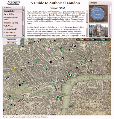
Dr. Martin Evans, professor in the English department here at Stanford, has already built a comprehensive Web 1.0 site detailing the lives of various literary personages who lived in or visited London. Authorial London, which will be publicly released at the end of this year, is an interactive and map-enabled version of that same data. The narratives for each author have been split up and associated with locations, so that when you click on the authors you can see their biography and a map of the locations associated with them, and if you click on the locations then you’ll be able to read about the various authors whose lives happened to have intersected with that location.
Authorial London was built in Flex, with a MySQL database storing the authors, locations, narratives and other data.

Mapping the Republic of Letters Database Migration
Based in the Humanities Center, the Mapping the Republic of Letters project is a multi-institution exploration into the intellectual history of the Enlightenment. Working with Nicole Coleman, we managed to transition the existing database to a novel and highly functional graph data model, allowing for an increase in the variety of data stored as well as the robustness necessary to deal with humanities data, which is notoriously asymmetrical, asynchronous and ambiguous.

Within the database itself, every object displayed in this interface is fundamentally the same, whether it is a person, letter, location, route, narrative or historical map. The only variation occurs in the number, type and quality of attributes attached to each entity, which varies across and within each category.
A subproject of the Mapping the Republic of Letters project, this focused on entering and analyzing spatial data related to travel in the Italian peninsula during the 18th century.

Mapping the Grand Tour Location Interface

Mapping the Grand Tour Route Interface